Yellow Trail - LBJ National Grasslands
Parking and camping at the TADRA Point Trailhead is $10 per day (as of October 2022). Cash payments can be made in a deposit box or you can pay with your smartphone by scanning an available QR code. An annual day use pass is also available from the Forest Service at the cost of $30 per year. The TADRA Point Trailhead has vault toilets if you would rather not take care of your business while on the trail.
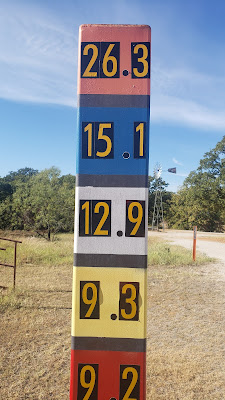
TADRA Point serves as the trailhead for five different trails ranging in length from 9 miles to 26 miles. These color coded trails are the Red, Blue, White, Yellow, and Orange trails. My hike took me on the Yellow Trail. While this trail is officially listed as 9.3 miles, my GPS tracked it at 9.7 miles.
The Yellow Trail contains a variety of landscapes. One moment you are hiking through grasslands. Next you are hiking through a forest filled with trees typical of the Cross Timbers region such as oak, elm, and cedar. Despite its designation as a grassland, there is lots of forest in the LBJ National Grasslands.
The trails on the LBJ Grasslands are well maintained and marked. While not impossible, getting lost is not likely as the trails are regularly marked. Markings include ribbons tied to vegetation, painted blazes, and mile markers. Cell service is intermittent, so best to also have maps downloaded to your phone or available on paper.
If you choose to hike the Yellow Trail or any of the other trails at LBJ, there are a few things to keep in mind. You will be sharing the land and trail with more than your fellow hikers. The trailhead was constructed through the efforts of local equestrian groups, thus the trails are used by horse riders. Since the grasslands are public land, they are used by hunters. While wearing fluorescent orange is only mandatory for hunters, it is also a wise practice for hikers. Controlled burns are a regular occurrence on the grasslands. There are also regular public events such as trail rides and trail runs. It would be wise to check Facebook or contact the Forest Service office in Decatur prior to your hike to ensure that none of these will be taking place.
LBJ National Grasslands offers a wonderful hiking experience. The only grievance I have against these trails is the sand. There's a lot of it! It slows your pace and fills your shoes. It shouldn't discourage you from hiking here, but in the interest of full disclosure I want to share the good and not so good about hiking at LBJ.
With its many miles of trail and variety of landscapes, the LBJ National Grasslands is one of the best locations for hiking in the Texoma region. If you are torn between the Red Trail and Yellow Trail, I'd recommend the Yellow Trail. Overall these two trails offer comparable experiences, but the Yellow Trail's pine forest is a big draw for this reviewer.
More information:


.jpg)
